Welcome to visit Journal of Shaanxi Normal University(Natural Science Edition)!

Characteristics of temporal succession of compound erosion by wind and water on slope cropland in rolling hill regions with black soil in northeastern China

  • YANG Wenbo 1, 2 ,
  • LIU Na 1 ,
  • SUN Liying , 2, 3, * ,
  • FENG Ziheng 2, 3 ,
  • CAI Qiangguo 2, 3
Expand
  • 1 College of Bioengineering, Henan University of Technology, Zhengzhou 450001, Henan, China
  • 2 Key Laboratory of Water Cycle and Related Land Surface Processes, Institute of Geographic Sciences and Natural Resources Research, Chinese Academy of Sciences, Beijing 100101, China
  • 3 College of Resources and Environment, University of Chinese Academy of Sciences, Beijing 100049, China

Received date: 2024-01-02

  Online published: 2025-04-22

Abstract

Compound erosion by multiple forces is the most significant feature of soil erosion on slope cropland in rolling hill regions with black soil in northeastern China. Compound erosion by wind and water is one of the important erosion types to aggravate the effects of soil erosion on slope cropland. In this study, on the experimental slope cropland in rolling hill regions, field observations of meteorological conditions, wind erosion and water erosion, and statistical methods were used to reveal the intra-annual alteration of erosion forces on compound erosion by wind and water and to analyze the intra-annual temporal succession characteristics of wind erosion and water erosion.Based on the threshold of wind speed for sand saltation (5 m/s) and erosive rainfall amount (12 mm/d) in rolling hill regions with black soil in northeastern China, the criteria for dividing the wind-dominated force and rainfall-dominated force of complex erosion on the experimental slope cropland was determined. The alteration of erosion forces of compound erosion by wind and water on the experimental slope cropland was divided into three stages: wind-dominated period Ⅰ(WDⅠ: Mid-March to Mid-July), rainfall-dominated period (RD: Mid July to Early October), wind-dominated period Ⅱ(WDⅡ: Early October to Mid-November). Surface creep erosion by wind accounted for about 92.95% of the total erosion amount by wind on the experimental slope cropland. Wind erosion rate in wind-dominated period was calculated at 432.9 g/m2 in WDⅠ and 40.95 g/m2 in WDⅡ. The rainfall erosion rate in rainfall-dominated period was estimated at 485.15 g/m2.The wind erosion and water erosion on the experimental slope cropland showed temporal succession characteristics with the intra-annual alternations of erosion forces, following the order of water erosion rate in RD > wind erosion rate in WDⅠ>wind erosion rate in WDⅡ.

Cite this article

YANG Wenbo , LIU Na , SUN Liying , FENG Ziheng , CAI Qiangguo . Characteristics of temporal succession of compound erosion by wind and water on slope cropland in rolling hill regions with black soil in northeastern China[J]. Journal of Shaanxi Normal University(Natural Science Edition), 2025 , 53(2) : 1 -12 . DOI: 10.15983/j.cnki.jsnu.2025101

东北黑土区土地肥沃、生产力高,被誉为“耕地中的大熊猫”[1]。同时,东北黑土区是我国重要的商品粮基地,粮食产量约占全国产量的1/5,为中国粮食安全提供了重要保障[2]。东北黑土区独特的自然地理环境和不合理的人类开垦活动,导致黑土区水土流失严重,危害耕地质量[3]。中华人民共和国2022年水土保持公报调查结果显示,东北黑土区的水土流失面积达到21.15万km2,其中风蚀面积达到7.66万km2,水蚀面积达到13.49万km2[4]。漫川漫岗黑土区的水土流失面积达到5.65万km2,占漫川漫岗黑土区面积的48.96%[5]。刘凯等[5]调查表明,近40年来,东北黑土区黑土层厚度平均减少了12 cm,黑土层平均下降速度为0.32 cm/a。黑土有机质含量也从3%~6%下降至1.5%~4.5%,约10%农耕地黑土层流失殆尽,出现“破皮黄”现象[6]。黑土层厚度和黑土有机质含量的下降是导致土壤退化的重要原因[7],耕层有机质含量每下降0.5%可导致粮食产量降低15%[8]
东北漫川漫岗黑土区坡耕地受冻融、风力和降雨等多种侵蚀营力影响,加剧了坡耕地土壤侵蚀过程的复杂性[9-12]。其中,风水复合侵蚀是风力和水力共同或交替作用于同一对象而形成的有别于单一风力或单一水力作用导致的土壤侵蚀,是东北黑土区坡耕地重要的复合侵蚀形式[13];实质上是一种侵蚀营力的作用为另一种侵蚀营力的再作用提供了基础,即在风力侵蚀的基础上又发生了水力侵蚀,或在水力侵蚀的基础上又发生了风力侵蚀[14]。桑琦明[15]根据侵蚀强度把风水复合侵蚀分为3个主要类型:风力侵蚀为主的侵蚀过程、水力侵蚀为主的侵蚀过程、风力和水力作用相当的侵蚀类型。黑土区春季和晚秋时节多为大风天气,3~5月份的大风天数占比最高,风速最大可以达到20~25 m/s[16];而夏季和初秋时节多为降雨天气,70%~80%降水集中在6~9月,主要发生水力侵蚀,且降雨历时短、降雨强度大,造成严重水土流失[17-18]。黑土区这种复杂多变的天气形成了黑土区特有的风力作用与水力作用在季节更替和空间位置的叠加特征[17]。风水复合侵蚀时间接续特征和空间叠加作用机制已成为目前东北黑土区坡耕地复合侵蚀研究的难点和重点[19]。已有学者通过模拟试验发现,前期的坡面水蚀使地表产生了明显的抗风蚀效应,输沙量和蠕移量显著降低;而前期坡面的风蚀为水蚀提供了物质基础,使坡面产流时间和产流量增加[14]。也有研究表明风力作用可通过改变地表微观结构加剧坡面径流量和水蚀量[14,20-21]。然而,目前东北黑土区坡耕地风水复合侵蚀机理仍处于初期探讨阶段,对东北黑土区风水复合侵蚀的空间叠加作用机制研究相对较多,而对风水复合侵蚀的时间接续特征量化研究相对薄弱[22]
本研究选定东北漫川漫岗黑土区坡耕地,将野外实地监测与统计分析相结合,划分风力作用和水力作用主导时期并分析不同时期侵蚀营力特征,探析东北黑土区坡耕地风蚀量和水蚀量年内时间接续变化。

1 研究区概况
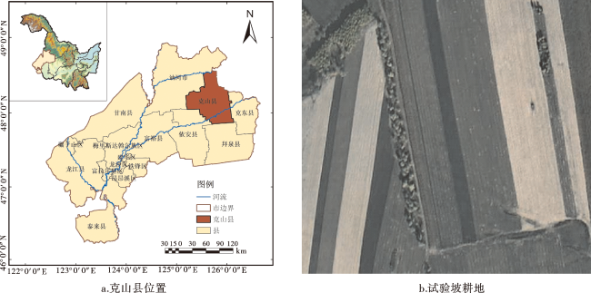
图1所示,试验坡耕地位于黑龙江省齐齐哈尔市克山县(48°05'32″N,125°83'82″E),属松嫩平原腹地典型的漫川漫岗区[23],土质较为松软,由于坡面汇流面积大,耕地指数较高且多为顺坡垄作,导致坡面水土流失问题严重[24]。克山县属寒温带大陆季风气候,年均气温2.4 ℃,年均降雨量500 mm,雨热同季集中于6~9月,春秋季风力作用强烈,最大风力可达15级。所选试验坡耕地地势呈东北高西南低的趋势,黑土层平均厚度为20 cm[25]。试验坡耕地2022年和2023年均种植大豆作物,耕作方式为顺坡垄作。
图1 试验坡耕地位置

注:网络版为彩图。

Fig.1 Location of the experimental slope cropland

2 材料与方法

2.1 侵蚀营力主导期的划分

漫川漫岗黑土区土壤侵蚀几乎全年发生,主导侵蚀营力在年内呈季节交替特征。本研究依据大于起沙风速(地表土壤颗粒由静止状态转化到运动状态)天数占比与侵蚀性降雨(大于侵蚀降雨量)天数占比确定风力主导作用时期与降水主导作用时期。东北黑土区起沙风速为5 m/s,侵蚀性降雨量为12 mm[26-27]。监测时期内,当日最大风速大于起沙风速(5 m/s)天数占比高于侵蚀性降雨(>12 mm)天数占比时,该段监测时期为风力主导期,主导营力为风力作用;反之该段监测期为降雨主导期,主导营力为降雨作用。

2.2 风水复合侵蚀营力监测

为探析漫川漫岗黑土区坡耕地风水复合侵蚀营力的时间接续特征,于2022年10月在克山粮食沟小流域试验坡耕地安装风速风向传感器(S-WCF-M003)和雨量筒(S-RGB-M002)(图2)。风速风向传感器的测量参数为风速、阵风风速和风向,测量范围是0~76 m/s,分辨率为0.5 m/s,精度为±1 m/s;雨量筒测量范围为0~127 mm/h,分辨率为0.2 mm,精度为±1%(20 mm/h);数据采集器(H21-USB-HOBO)的工作温度为—20~50 ℃,时间精度5 s/周,内置512 kB储存器。以上3种仪器均产自美国ONSET公司。坡长是影响东北漫川漫岗区土壤侵蚀的重要因素[28],导致土壤侵蚀随坡位变化而呈现侵蚀与沉积的差异[29]。据此,根据试验坡耕地坡顶到坡脚的距离,将试验坡耕地平均分为三部分,即上坡、中坡和下坡。为分析不同坡位风力作用的差异,分别在上坡和中坡安装风速风向传感器。风速风向传感器安装在硬质钢管上,在钢管不同高度(1 m、1.5 m和1.8 m)安装风速风向传感器可监测坡耕地不同高度风力作用(图2)。由于2022年中坡位置1.5 m高度处风速风向传感器需返厂维修,未获得2022年秋季(2022年10月8日~2023年3月13日)相关监测数据,后续研究中不涉及1.5 m处风速数据分析。
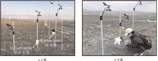
图2 试验坡耕地野外风力和降雨特征监测

Fig.2 Monitoring of wind and rainfall characteristics on the experimental slope cropland

2.3 坡耕地风蚀和水蚀强度监测

2.3.1 坡耕地风力侵蚀监测

2022年9月末,对克山试验坡耕地中种植的大豆进行收割、灭茬、翻地、耙地,等待土壤晾干后,再次对农田进行起垄作业(如图3所示)。2022年10月,在克山试验坡耕地不同坡位(上坡、中坡、下坡)布置风蚀钢钎观测小区(5 m×1 m)以监测试验坡耕地不同坡位风蚀量(图3)。每个风蚀观测小区内部布设54根钢钎,钢钎露出地面的初始高度为10 cm,其中顺坡耕作垄台布设27根、垄沟布设27根。2022年秋冬季(2022年10月1日至11月30日)及2023年春夏季(2023年3月1日至2023年7月30日),间隔7天对不同坡位风蚀观测小区内的钢钎进行测量。同时,间隔14天对不同坡位风蚀观测小区进行环刀取样,计算得到坡耕地平均土壤容重(1.17±0.02 g/cm3)。在不同时期,根据出露钢钎高度相对变化的累积平均值计算监测期内坡耕地风蚀量。
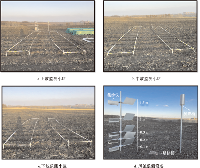
图3 试验坡耕地风蚀钢钎监测小区和BSNE风蚀监测设备

Fig.3 Field wind erosion steel monitoring plots and BSNE wind erosion monitoring equipment on the experimental slope cropland

利用BSNE风蚀特征观测设备进行风蚀输沙、蠕移和沉降特征观测[30]。2022年10月在试验坡耕地上坡位置安装BSNE风蚀监测设备(图3),包括BSNE集沙仪、蠕移桶和沉降桶。其中,集沙仪进沙口面积为20 mm×50 mm,安装在离地面0.1、0.3、0.5、1.0、1.5 m高度处;蠕移桶直径16 cm,深度为30 cm,通过“陷阱诱捕法”对地表风蚀蠕移量进行收集;沉降桶(直径16 cm,深度30 cm),安装高度2 m,收集大气沉降颗粒。分别在2022年秋冬季及2023年春夏季(2022年11月15日、2023年4月15日、5月9日、5月17日和6月26日)对试验坡耕地中集沙仪、蠕移桶和沉降桶中的样品进行收集,以分析试验坡耕地风蚀输沙、蠕移和沉降特征。

2.3.2 坡耕地水力侵蚀监测
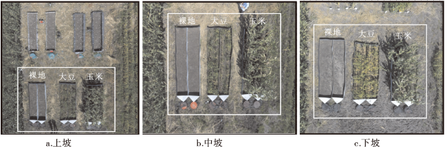
图4所示,2022年10月在试验坡耕地不同坡位(上坡、中坡、下坡)布置水蚀观测小区(5 m×1 m),以监测试验坡耕地不同坡位水力侵蚀强度。水蚀小区的主要材料是碳钢铁皮,碳钢铁皮深埋地下30 cm,露出地面20 cm。不同坡位布置裸地、大豆和玉米3种径流小区。
图4 试验坡耕地野外径流观测小区

Fig.4 Field runoff observation plots on the experimental slope cropland

2.4 数据处理与分析

统计分析均采用SPSS Statistics 27.0 分析软件完成。不同坡位和不同高度的风速数据显著性差异分析采用成对t检验分析,不同坡位降雨侵蚀径流量和含沙量数据间的显著性差异分析采用单因素方差分析(ANOVA),事后比较选用最小显著差异法和沃勒-邓肯检验(W),可信度设定为95%(P<0.05)。所有作图均使用Origin 2023绘制。

3 结果与分析

3.1 风水复合侵蚀营力特征

3.1.1 时间接续特征

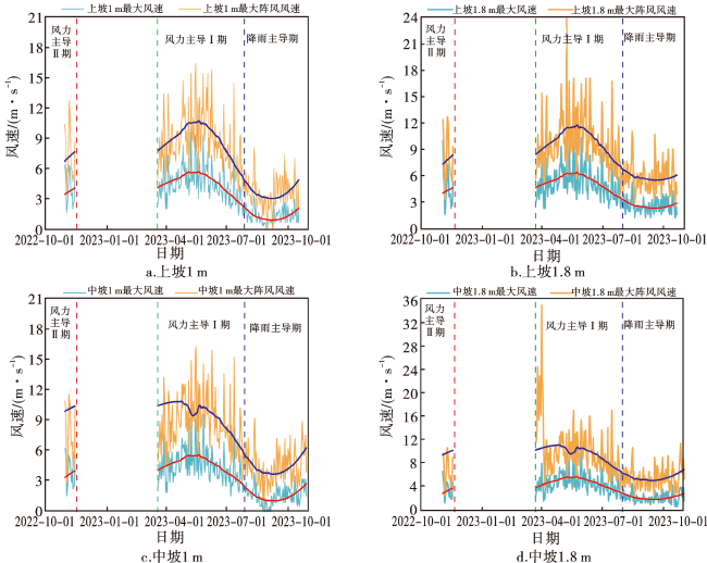
根据试验坡耕地野外气象条件监测数据和侵蚀营力主导作用划分标准,试验坡耕地风水复合侵蚀营力年内时间接续特征可划分为3个时期(图5):1)风力主导Ⅰ期(2023年3月中旬至7月中旬),侵蚀营力以风力作用主导;2)降雨主导期(2023年7月中旬至10月上旬),侵蚀营力以降雨作用为主导;3)风力主导Ⅱ期(2022年10月上旬至11月中旬),侵蚀营力以风力作用为主导。
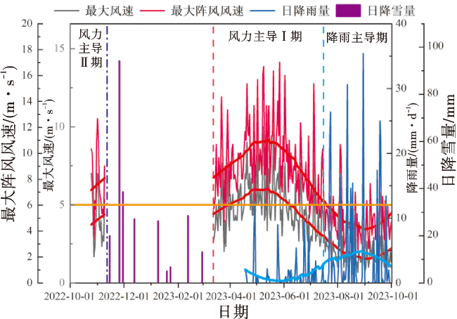
图5 漫川漫岗黑土区坡耕地风水复合侵蚀营力年内时间接续特征

注:网络版为彩图。

Fig.5 Intra-annual temporal succession of erosion force on compound erosion by wind and water on the experimental slope cropland in rolling hill regions with black soil

3个时期主导营力的特征见表1:1)风力主导Ⅰ期(3月中旬至7月中旬),日最大风速大于起沙风速的天数占比为42.7%(56 d),监测期内日最大风速范围为1.34~11.02 m/s,日最大阵风风速范围为3.67~35.12 m/s,平均风速为4.85 m/s,监测期内侵蚀性降雨事件占比为0.76%(1 d),此时正值春播前后,春播导致坡耕地裸露和土壤粒径组成改变,加剧了风力侵蚀;2)风力主导Ⅱ期(10月上旬至11月中旬),日最大风速大于起沙风速的天数占比为61.1%(22 d),监测期内日最大风速范围为1.67~10.02 m/s,日最大阵风风速范围为3.01~12.69 m/s,平均风速为4.32 m/s,监测期内无降水事件发生,该时期与秋收活动叠加,秋收后土地裸露加剧了风力侵蚀;3)降雨主导期(7月中旬至10月上旬),共发生35次降雨事件,日降雨量为0.2~35.4 mm,平均日降雨量为3.73 mm,侵蚀性降雨事件发生占比为12.27%(12次),日最大风速大于起沙风速的天数占比为0,以水力侵蚀为主导。
表1 漫川漫岗黑土区不同时期试验坡耕地风水复合侵蚀营力特征

Tab.1 Characteristics of the erosion force of compound erosion by water and wind on the experimental slope cropland in different periods in rolling hill regions with black soil

特征 风力主导Ⅰ期 风力主导Ⅱ期 降雨主导期
日期 3月中旬~7月中旬 10月上旬~11月中旬 7月中旬~10月上旬
日最大风速/(m·s-1) 1.34~11.02 1.67~10.02 0.67~4.37
日最大阵风速/(m·s-1) 3.67~35.12 3.01~12.69 2.34~11.69
平均风速/(m·s-1) 4.85 4.32 2.05
日降雨量/mm 0.2~12.4 0 0.2~35.4
平均日降雨量/mm 0.95 0 3.73
大于起沙风速天数占比/% 42.7 61.1 0
侵蚀性降雨天数占比/% 0.76 0 12.27

3.1.2 风速分布特征

试验坡耕地风力主导Ⅰ期不同坡位和不同高度最大风速和最大阵风风速变化范围分别为1.34~11.02 m/s、3.67~35.12 m/s(表2),均呈先升高后降低的变化特征(图6)。试验坡耕地风力主导Ⅰ期最大风速和阵风风速峰值均出现在3~5月份,这与吴淑梅[31]的研究结果类似,该研究发现自1964年至2018年东北地区的大风日数逐渐减少,每年3~5月份的大风天气最多且风速较大。试验坡耕地风力主导Ⅱ期不同坡位和不同高度最大风速和最大阵风风速变化范围分别为1.67~10.02 m/s和3.01~12.69 m/s(表2),均呈持续升高的变化特征,峰值出现在10月(图6)。研究结果表明风力主导Ⅰ期的最大风速和最大阵风风速均高于风力主导Ⅱ期,但无显著性差异。如表2所示,风力主导Ⅰ期和Ⅱ期,同一高度不同坡位最大风速和最大阵风风速均无显著性差异,相同坡位不同高度最大风速和最大阵风风速亦无显著性差异。试验坡耕地风力主导期(WD Ⅰ和WDⅡ)的最大风速和最大阵风风速峰值出现在4月和10月,且春季风速>秋冬季风速,与Pei等[32]研究结果相似,该研究发现2001—2020年典型黑土风水复合侵蚀区月最大风速时间变化均呈“双峰”趋势,峰值分别出现在4月和10月,风速季节变化趋势为春季>秋季>冬季>夏季。
表2 风力主导Ⅰ期(WDⅠ)和风力主导Ⅱ期(WDⅡ)不同坡位和不同高度风速特征

Tab.2 Wind speed characteristics of different slope positions and different heights in WDⅠ and WDⅡ

坡位与传感器高度 上坡位1 m 中坡位1 m 上坡位1.8 m 中坡位1.8 m
WDⅠ日平均最大风速/(m·s-1) 4.59±1.67Aa* 4.70±1.62Aa* 5.33±1.79Aa* 5.12±1.69Aa*
WDⅠ日平均最大阵风风速/(m·s-1) 8.89±2.76Aa# 10.15±4.06Aa# 9.95±3.09Aa# 10.7±4.33Aa#
WDⅡ日平均最大风速/(m·s-1) 4.25±1.85Aa* 3.88±1.53Aa* 4.68±2.15Aa* 4.09±1.49Aa*
WDⅡ日平均最大阵风风速/(m·s-1) 7.48±2.59Aa# 7.16±2.5Aa# 8.15±2.75Aa# 7.64±2.77Aa#
WDⅠ日最大风速/(m·s-1) 1.34~10.02 1.67~9.68 2.34~11.02 2.00~10.69
WDⅠ日最大阵风风速/(m·s-1) 3.67~16.36 4.34~32.86 5.01~23.71 4.34~35.12
WDⅡ日最大风速/(m·s-1) 1.67~8.21 1.67~6.35 1.67~10.02 1.67~7.01
WDⅡ日最大阵风风速/(m·s-1) 3.34~12.69 3.01~11.69 3.34~12.69 3.01~11.02

注:不同小写字母表示日最大风速、日阵风风速在相同高度上坡和中坡之间呈显著性差异(P<0.05);不同大写字母表示日最大风速、日阵风风速在相同坡位不同高度1 m和1.8 m之间呈显著性差异(P<0.05);*、#表示日均最大风速和日均最大阵风风速在风力主导Ⅰ期和风力主导Ⅱ期之间呈显著性差异(P<0.05)。

图6 漫川漫岗黑土区试验坡耕地不同坡位和不同高度风速

注:网络版为彩图。

Fig.6 Wind speeds at different slope locations and different heights on the experimental slope cropland in rolling hill regions with black soil

3.2 风力和水力侵蚀年内接续特征

3.2.1 风力侵蚀

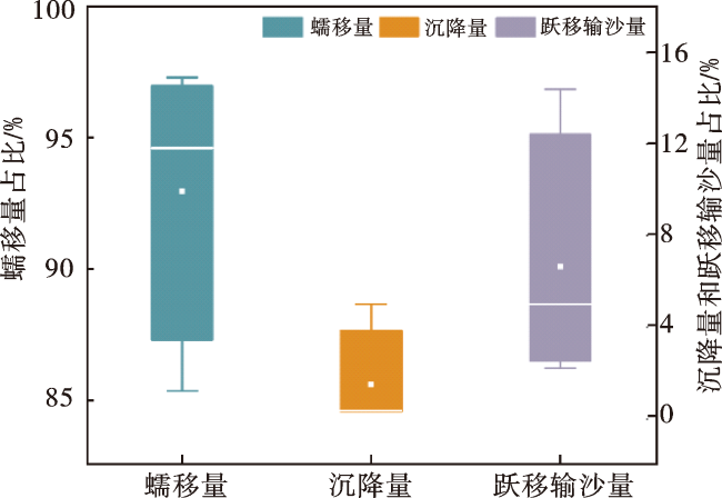
图7可见,风力主导期试验坡耕地风力侵蚀以地表风蚀蠕移为主,占比92.95%±5.4%,跃移输沙占比为5.55%±5.5%,风沙沉降占比1.5%±2.3%。杨润城[30]对黑龙江省海伦市的农田风蚀监测结果发现,黑土区坡耕地地表风蚀蠕移量约为19.18 kg/m2且远高于跃移输沙量和风沙沉降量,与本文结果基本一致。表3中,风力主导Ⅰ期试验坡耕地平均土壤流失厚度为0.037±0.006 1 cm,侵蚀速率为432.90 g/m2,风力侵蚀主导Ⅱ期试验坡耕地平均土壤流失厚度为0.003 5±0.001 4 cm,侵蚀速率为40.95 g/m2。不同坡位风力侵蚀速率在不同时期存在差异:风力主导Ⅰ期风力侵蚀速率符合下坡(530.80 g/m2)>上坡(381.94 g/m2)>中坡(375.95 g/m2),而风力主导Ⅱ期风力侵蚀速率符合下坡(63.94 g/m2)>中坡(32.96 g/m2)>上坡(25.68 g/m2)。由此可见,试验坡耕地风力主导期侵蚀速率在下坡位最高,受试验坡耕地坡形、坡度和风向共同作用。风蚀发育过程分为迎风面底角侵蚀、迎风面坡面侵蚀、背风面底角侵蚀、顶部侵蚀4个阶段[33]。本研究中,试验坡耕地为典型的迎风坡,风蚀发育处于底角侵蚀阶段,导致下坡位的风蚀相对较高。Whitney[34]的观测结果同样说明,坡面在盛行风向期间,尾部的风蚀要比顶部的风蚀严重。试验坡耕地的坡形为凸形坡,沈影利[35]的研究结果表明,凸形坡的风蚀速率在坡底最大,而水蚀速率在坡底最小,凸形坡为迎风坡,风力作用部位主要在坡底。风力主导Ⅰ期试验坡耕地上、中、下三个坡位的侵蚀速率显著高于风力主导Ⅱ期。风力作用强度及风力作用时间决定了风力侵蚀的程度,风力作用时间越长、风速越大,风力侵蚀速率越强[36]。本研究中风力主导Ⅰ期的年内时间占比为34.2%,而风力主导Ⅱ期的年内时间占比为9.6%,相较于风力主导Ⅱ期,风力主导Ⅰ期的作用时间相对较长,风力主导Ⅰ期的侵蚀速率强于风力主导Ⅱ期。
表3 试验坡耕地风力主导期不同坡位风蚀观测小区风蚀钢钎平均变化量与风力侵蚀速率

Tab.3 The average change of wind erosion steel brazing in the wind erosion observation plots and the wind erosion rate at different slope positions of the experimental slope cropland during the wind-dominated periods

观测项目 风力主导Ⅰ期 风力主导Ⅱ期
上坡位钢钎高度变化/cm 0.033±0.017 0.002 2±0.000 9
中坡位钢钎高度变化/cm 0.032±0.011 0.002 8±0.001 2
下坡位钢钎高度变化/cm 0.045±0.026 0.005 5±0.002 7
上坡位平均侵蚀速率/(g·m-2) 381.94 25.68
中坡位平均侵蚀速率/(g·m-2) 375.95 32.96
下坡位平均侵蚀速率/(g·m-2) 530.80 63.94
试验坡耕地土壤流失厚度/cm 0.037±0.006 1 0.003 5±0.001 4
试验坡耕地的侵蚀速率/(g·m-2) 432.90 40.95
图7 风力主导期试验坡耕地风蚀特征

注:网络版为彩图。

Fig.7 Wind erosion characteristics on the experimental slope cropland during the wind-dominated periods

3.2.2 水力侵蚀

图8所示,裸地径流小区夏季降雨侵蚀量为2 425.73 g,平均侵蚀速率为485.15 g/m2,随时间变化规律遵循8月降雨侵蚀量(1 371.42 g)>9月降雨侵蚀量(1 031.55 g)>7月降雨侵蚀量(22.76 g)。玉米径流小区和大豆径流小区降雨侵蚀量随时间变化亦遵循8月降雨侵蚀量>9月降雨侵蚀量>7月降雨侵蚀量。3种径流小区降雨侵蚀量随时间变化规律与降雨量随时间变化规律(8月163.4 mm>9月89 mm>7月70.4 mm)一致。已有研究表明[37-38]土壤流失量与降雨量呈显著正相关,这与本研究结果基本一致。此外,降雨强度增加亦可导致黑土区土壤侵蚀增强。雨强越大,降雨动能和侵蚀力越大[39],坡面径流作用增强,土壤颗粒搬运能力增强,土壤侵蚀量也随之增大[40]。张宪奎等[41]研究发现,短历时和高雨强的降雨是导致黑土区水土流失的主要原因。本研究中,8月降雨量(10.89 mm/d)远高于7月(7.04 mm/d)和9月(8.09 mm/d),导致不同类型径流小区在8月侵蚀速率最高。如图8所示,裸地径流观测小区的产流量和产沙量均高于玉米和大豆径流小区,农田作物对水土流失具有一定的抑制作用[42],增加作物的覆盖度可以减少水力侵蚀的危害。
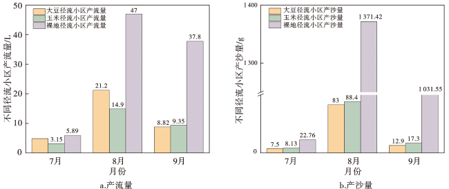
图8 试验坡耕地降雨主导期不同径流小区自然降雨的产流量和产沙量

注:网络版为彩图。

Fig.8 Runoff and sediment yield in different plots during the rainfall-dominated period on the experimental slope cropland

3.2.3 风力和水力侵蚀年内接续

漫川漫岗黑土区试验坡耕地风水复合侵蚀主导营力随季节交替作用而呈现风力主导Ⅰ期(3月中旬~7月中旬)、降雨主导期(7月中旬~10月上旬)和风力主导Ⅱ期(10月上旬~11月中旬)年内时间接续特征。漫川漫岗黑土区试验坡耕地风水复合侵蚀量随主导营力交替变化呈现风力侵蚀和水力侵蚀年内接续特征,降雨主导期侵蚀速率(485.15 g/m2)>风力主导Ⅰ期侵蚀速率(432.9 g/m2)>风力主导Ⅱ期侵蚀速率(40.95 g/m2)。试验坡耕地风力侵蚀占全年风水复合侵蚀量的49.41%,其中,风力主导Ⅰ期的风力侵蚀占比为91.36%,风力主导Ⅱ期的侵蚀占比为8.64%;试验坡耕地水力侵蚀占全年侵蚀量50.59%。已有研究表明,东北黑土区的降雨侵蚀量占全年侵蚀量的70%左右,风力侵蚀量占全年侵蚀量的20%~30%[43]。这与本研究得出的规律大体一致,但本研究中降雨主导期侵蚀速率年内占比略有减少,具体原因有:试验坡耕地所在区域2023年整体降雨量较少,降雨主导期降雨量仅有322.8 mm,导致所观测降雨主导期水力侵蚀量较低;此外,试验坡耕地平均坡度仅为1.87°±0.2°,缓坡导致观测降雨主导期水力侵蚀量较低。已有研究表明[44],黑土区长坡缓坡的地形条件下,坡面径流流速和径流持沙力随坡度的减缓而降低,相同降雨条件下,缓坡土壤入渗能力增加,径流量和产沙量减少。本研究中试验径流小区坡长较短(5 m),所观测水力侵蚀量相对低于长坡水力侵蚀观测量。

4 结论

1)漫川漫岗黑土区坡耕地侵蚀营力呈季节交替时空变化特征,可划分为3个时期,即风力主导Ⅰ期(3月中旬~7月中旬)、降雨主导期(7月中旬~10月上旬)和风力主导Ⅱ期(10月上旬~11月中旬),年内时间占比分别为34.2%、23%和9.6%。其中,风力主导Ⅰ期的日最大风速为1.34~11.02 m/s,大于起沙风速的天数占比为42.7%;降雨主导期的日降雨量为0~35.4 mm,侵蚀性降雨事件的占比为12.27%;风力主导Ⅱ期的日最大风速为1.67~11.02 m/s,大于起沙风速的天数占比为61.1%。
2)漫川漫岗黑土区试验坡耕地风水复合侵蚀量随主导营力时间接续而呈现风力侵蚀和水力侵蚀随季节交替的年内接续特征,降雨主导期水力侵蚀速率>风力主导Ⅰ期风力侵蚀速率>风力主导Ⅱ期风力侵蚀速率。坡耕地全年的土壤侵蚀量以降雨侵蚀量为主,风力侵蚀量次之。根据2022—2023年的观测数据,试验坡耕地的降雨侵蚀主要发生夏季和初秋,降雨主导期侵蚀量占比为50.59%;风力侵蚀主要发生在春季和晚秋,风力主导Ⅰ期侵蚀量占比为45.14%,风力Ⅱ期侵蚀量占比为4.27%。
3)本文基于2022—2023年野外试验坡耕地监测数据量化分析了风水复合侵蚀营力年内季节交替作用及风力侵蚀和水力侵蚀在侵蚀营力季节交替作用下呈现的时间接续特征,存在野外观测时间短、所选试验坡耕地坡度较缓、径流小区的坡长较短等局限性。未来仍需结合长期历史气象数据与长期野外观测数据,进一步深入分析漫川漫岗黑土区风水复合侵蚀时间接续过程及其对气象、地形和植被覆盖等多因素的响应机制。
[1]
付丽丽. 守护好“耕地中的大熊猫”[N]. 科技日报,2023-08-29.

[2]
刘宝元, 阎百兴, 沈波, 等. 东北黑土区农地水土流失现状与综合治理对策[J]. 中国水土保持科学, 2008, 6(1): 1-8.

LIU B Y, YAN B X, SHEN B, et al. Current status and comprehensive control strategies of soil erosion for cultivated land in the Northeastern black soil area of China[J]. Science of Soil and Water Conservation, 2008, 6(1):1-8.

[3]
LIU B Y, XIE Y, LI Z G, et al. The assessment of soil loss by water erosion in China[J]. International Soil and Water Conservation Research, 2020, 8(4): 430-439.

[4]
中华人民共和国水利部. 2010年中国水土保持公报[J]. 中华人民共和国水利部公报, 2012(1): 22-35.

Ministry of Water Resources of the People’s Republic of China. China Soil and Water Conservation Bulletin 2010[J]. Gazette of the Ministry of Water Resources of the People’s Republic of China, 2012(1): 22-35.

[5]
刘凯, 魏明辉, 戴慧敏, 等. 东北黑土区黑土层厚度的时空变化[J]. 地质与资源, 2022, 31(3): 434-442,394.

LIU K, WEI M H, DAI H M, et al. Spatiotemporal variation of black soil layer thickness in black soil region of Northeast China[J]. Geology and Resources, 2022, 31(3): 434-442,394.

[6]
李发鹏, 李景玉, 徐宗学. 东北黑土区土壤退化及水土流失研究现状[J]. 水土保持研究, 2006, 13(3): 50-54.

LI F P, LI J Y, XU Z X. The status quo of black soil degradation and water and soil loss in Northeast China[J]. Research of Soil and Water Conservation, 2006, 13(3): 50-54.

[7]
杨文博, 刘娜, 蔡强国, 等. 水力侵蚀对土壤碳循环及土壤微生物多样性影响的研究进展[J]. 水土保持学报, 2024, 38(1): 14-21.

YANG W B, LIU N, CAI Q G, et al. Research progress on the effects of hydraulic erosion on soil carbon cycle and soil microbial diversity[J]. Journal of Soil and Water Conservation, 2024, 38(1): 14-21.

[8]
韩晓增, 邹文秀, 杨帆. 东北黑土地保护利用取得的主要成绩、面临挑战与对策建议[J]. 中国科学院院刊, 2021, 36(10): 1194-1202.

HAN X Z, ZOU W X, YANG F. Main achievements,challenges,and recommendations of black soil conservation and utilization in China[J]. Bulletin of Chinese Academy of Sciences, 2021, 36(10): 1194-1202.

[9]
张攀, 姚文艺, 刘国彬, 等. 土壤复合侵蚀研究进展与展望[J]. 农业工程学报, 2019, 35(24): 154-161.

ZHANG P, YAO W Y, LIU G B, et al. Research progress and prospects of complex soil erosion[J]. Transactions of the Chinese Society of Agricultural Engineering, 2019, 35(24): 154-161.

[10]
王一菲, 郑粉莉, 周秀杰, 等. 黑土农田冻结-融化期土壤剖面温度变化特征[J]. 水土保持通报, 2019, 39(3): 57-64.

WANG Y F, ZHENG F L, ZHOU X J, et al. Soil profile temperature variation in farmlands during freeze-thaw period in Mollisol region[J]. Bulletin of Soil and Water Conservation, 2019, 39(3): 57-64.

[11]
ZHANG X, ZHOU Q, CHEN W, et al. Observation and modeling of black soil wind-blown erosion from cropland in Northeastern China[J]. Aeolian Research, 2015,19: 153-162.

[12]
王计磊, 李子忠. 东北黑土区水力侵蚀研究进展[J]. 农业资源与环境学报, 2018, 35(5): 389-397.

WANG J L, LI Z Z. Research progress on water erosion in the black soil region of Northeast China[J]. Journal of Agricultural Resources and Environment, 2018, 35(5): 389-397.

[13]
SONG Y, YAN P, LIU L. A review of the research on complex erosion by wind and water[J]. Journal of Geographical Sciences, 2006,16: 231-241.

[14]
左小锋, 郑粉莉, 张加琼, 等. 典型薄层黑土区前期地表风蚀作用影响坡面水蚀的研究[J]. 土壤学报, 2021, 58(5): 1145-1156.

ZUO X F, ZHENG F L, ZHANG J Q, et al. Study on effect of surface wind erosion on hillslope water erosion in regions of typical thin layered Mollisol at early stages[J]. Acta Pedologica Sinica, 2021, 58(5): 1145-1156.

[15]
桑琦明. 典型厚层黑土区冻融-风力-水力叠加驱动的坡面侵蚀过程及其机理[D]. 杨凌: 西北农林科技大学, 2021.

SANG Q M. The processes and mechanisms of sloping soil erosion driven by freeze-thaw,wind and water agents in typical Chinese Mollisol region[D]. Yangling: Northwest A&F University, 2021.

[16]
沈波, 杨海军. 松辽流域水土流失及其防治对策[J]. 水土保持通报, 1993(2): 28-32.

SHEN B, YANG H J. Soil and water loss and it preventive measure in Song-Liao valley in Northeast China[J]. Bulletin of Soil and Water Conservation, 1993(2): 28-32.

[17]
贾燕锋, 王佳楠, 范昊明, 等. 东北黑土区水土保持措施防治多营力侵蚀的作用与优化配置[J]. 中国水土保持科学, 2022, 20(5): 124-132.

JIA Y F, WANG J N, FAN H M, et al. Effects and optimal allocation of soil and water conservation measures on the multi-agent combined soil erosion in the Mollisol region,Northeast China[J]. Science of Soil and Water Conservation, 2022, 20(5): 124-132.

[18]
范昊明, 蔡强国, 王红闪. 中国东北黑土区土壤侵蚀环境[J]. 水土保持学报, 2004, 18(2): 66-70.

FANG H M, CAI Q G, WANG H S. Condition of soil erosion in phaeozem region of Northeast China[J]. Journal of Soil and Water Conservation, 2004, 18(2): 66-70.

[19]
郑粉莉, 张加琼, 刘刚, 等. 东北黑土区坡耕地土壤侵蚀特征与多营力复合侵蚀的研究重点[J]. 水土保持通报, 2019, 39(4): 314-319.

ZHENG F L, ZHANG J Q, LIU G, et al. Characteristics of soil erosion on sloping farmlands and key fields for studying compound soil erosion caused by multi-forces in Mollisol region of Northeast China[J]. Bulletin of Soil and Water Conservation, 2019, 39(4): 314-319.

[20]
ISERLOH T, FISTER W, MARZEN M, et al. The role of wind-driven rain for soil erosion-an experimental approach[J]. Zeitschrift für Geomorphologie, 2013,57:193-201.

[21]
桑琦明, 郑粉莉, 王一菲, 等. 东北黑土区冻融、风力、水力交互作用对坡面侵蚀的影响[J]. 水土保持学报, 2021, 35(2): 87-95.

SANG Q M, ZHENG F L, WANG Y F, et al. An Experimental study on freeze-thaw,wind and water agents impacts on hillslope soil erosion in Chinese Mollisol region[J]. Journal of Soil and Water Conservation, 2021, 35(2): 87-95.

[22]
裴亮, 王春辉, 孙莉英. 黑土区土壤风水复合侵蚀机理研究进展及展望[J]. 环境科学与管理, 2022, 47(10): 181-185.

PEI L, WANG C H, SUN L Y. Research progress and prospect of soil erosion mechanism in black soil region of Northeast China[J]. Environmental Science and Management, 2022, 47(10): 181-185.

[23]
杨小垂, 王玉玺, 解运杰. 黑土区土壤侵蚀与土地利用关系分析:以黑龙江省克山县为例[J]. 水土保持研究, 2009, 16(1): 55-58.

YANG X C, WANG Y X, XIE Y J. Relationship between land use change and soil erosion in black soil-taking the county of Keshan,Heilongjiang province as an example[J]. Research of Soil and Water Conservation, 2009, 16(1): 55-58.

[24]
胡刚, 伍永秋, 刘宝元, 等. GPS和GIS进行短期沟蚀研究初探:以东北漫川漫岗黑土区为例[J]. 水土保持学报, 2004, 18(4): 16-19,41.

HU G, WU Y Q, LIU B Y, et al. Preliminary research on short-term channel erosion using GPS and GIS[J]. Journal of Soil and Water Conservation, 2004, 18(4): 16-19,41.

[25]
FANG H. Impacts of rainfall and soil conservation measures on soil,SOC,and TN losses on slopes in the black soil region,Northeastern China[J]. Ecological Indicators, 2021, 129:108016.

[26]
林艺, 李和平, 肖波. 东北黑土区农田土壤风蚀的影响因素及其数量关系[J]. 水土保持学报, 2017, 31(4): 44-50.

LIN Y, LI H P, XIAO B. Influencing factors of wind erosion and their quantitative relationships with erosion rate in black soil area of Northeast China[J]. Journal of Soil and Water Conservation, 2017, 31(4): 44-50.

[27]
谢云, 刘宝元, 章文波. 侵蚀性降雨标准研究[J]. 水土保持学报, 2000, 14(4): 6-11.

XIE Y, LIU B Y, ZHANG W B. Study on standard of erosive rainfall[J]. Journal of Soil and Water Conservation, 2000, 14(4): 6-11.

[28]
刘华征, 贾燕锋, 范昊明, 等. 东北松嫩典型黑土区长缓坡耕地土壤侵蚀沿坡长变化规律及其对土壤质量的影响[J]. 自然资源学报, 2022, 37(9): 2292-2305.

DOI

LIU H Z, JIA Y F, FAN H M, et al. Variation of soil erosion intensity along the long gentle farming slopes and its influence on soil quality in the typical Mollisol region,Songnen Plain,Northeast China[J]. Journal of Natural Resources, 2022, 37(9): 2292-2305.

[29]
孙莉英, 郑明国, 方海燕, 等. 漫川漫岗黑土区水土流失综合治理范式[J]. 中国水土保持科学, 2012, 10(3): 43-49.

SUN L Y, ZHENG M G, FANG H Y, et al. Paradigm of integrated soil and water conservation in rolling hill regions with black soil in Northeast China[J]. Science of Soil and Water Conservation, 2012, 10(3): 43-49.

[30]
杨润城. 海伦黑土农田风蚀监测研究[D]. 沈阳: 东北农业大学, 2018.

YANG R C. Monitoring study on wind erosion in Hailun of the typical Mollisols farmland in Northeast China[D]. Shenyang: Northeast Agricultural University, 2018.

[31]
吴淑梅. 1964年—2018年兴安盟大风日数变化特征[J]. 内蒙古科技与经济, 2020(6): 52-53.

WU S M. Characteristics of changes in the number of windy days in Hinggan League from 1964 to 2018[J]. Inner Mongolia Science Technology & Economy, 2020(6): 52-53.

[32]
PEI L, WANG C H, SUN L Y, et al. Temporal and spatial variation (2001-2020) characteristics of wind speed in the water erosion area of the typical black soil region,Northeast China[J]. International Journal of Environmental Research and Public Health, 2022, 19(17):10473.

[33]
WARD A, GREELEY R. Evolution of the yardangs at Rogers Lake,California[J]. Geological Society of America Bulletin, 1984, 95(7): 829-837.

[34]
WHITNEY M I. The role of vorticity in developing lineation by wind erosion[J]. Geological Society of America Bulletin, 1978, 89(1): 1-18.

[35]
沈影利. 风水复合侵蚀对不同坡型黑土坡耕地土壤质量的影响研究[D]. 杨凌: 中国科学院大学(中国科学院教育部水土保持与生态环境研究中心), 2023.

SHEN Y L. Study on the impact of wind and water combined erosion on soil quality in Mollisols sloping farmland with different slope shapes[D]. Yangling: University of Chinese Academy of Sciences (Research Center of Soil and Water Conservation and Ecological Environment,Chinese Academy of Sciences and Ministry of Education), 2023.

[36]
YANG Y Y, QU Z Q, SHI P J, et al. Wind regime and sand transport in the corridor between the Badain Jaran and Tengger deserts,central Alxa Plateau,China[J]. Aeolian Research, 2014,12: 143-156.

[37]
李飞, 韩兴, 马秀兰, 等. 秸秆覆盖对东北黑土区坡耕地产流产沙及氮磷流失的阻控[J]. 水土保持学报, 2020, 34(4): 37-42.

LI F, HAN X, MA X L, et al. Straw mulch controls runoff and nitrogen and phosphorus loss from slope farmland in black soil region of Northeast China[J]. Journal of Soil and Water Conservation, 2020, 34(4): 37-42.

[38]
励其其, 刘鸿涛, 孟岩, 等. 不同降雨强度和下垫面条件对黑土区坡面产流产沙的影响[J]. 水利水电技术, 2020, 51(5): 91-98.

GU Q Q, LIU H T, MENG Y, et al. Effects of different rainfall intensity and underlying surface conditions on runoff-sediment yield of slope surface within black soil region[J]. Water Resources and Hydropower Engineering, 2020, 51(5): 91-98.

[39]
蔡强国, 刘纪根, 刘前进. 岔巴沟流域次暴雨产沙统计模型[J]. 地理研究, 2004, 23(4): 433-439.

CAI Q G, LIU J G, LIU Q J. Research of sediment yield statistical model for single rainstorm in Chabagou drainage basin[J]. Geographical Research, 2004, 23(4): 433-439.

[40]
温永福, 高鹏, 穆兴民, 等. 黄土高原丘陵沟壑区梯田边坡侵蚀过程对雨强的响应[J]. 泥沙研究, 2017, 42(6): 46-51.

WEN Y F, GAO P, MU X M, et al. Response of soil erosion to rainfall intensity in terraced slope in the Loess Plateau[J]. Journal of Sediment Research, 2017, 42(6): 46-51.

[41]
张宪奎, 许靖华, 卢秀琴, 等. 黑龙江省土壤流失方程的研究[J]. 水土保持通报, 1992, 12(4): 1-9,18.

ZHANG X K, XU J H, LU X Q, et al. A study on the soil loss equation in Heilongjiang province[J]. Bulletin of Soil and Water Conservation, 1992, 12(4): 1-9,18.

[42]
佘冬立, 刘营营, 邵明安, 等. 黄土坡面不同植被冠层降雨截留模型模拟效果及适用性评价[J]. 农业工程学报, 2012, 28(16): 115-120.

SHE D L, LIU Y Y, SHAO M A, et al. Simulated effects and adaptive evaluation of different canopies rainfall interception models in Loess Plateau[J]. Transactions of the Chinese Society of Agricultural Engineering, 2012, 28(16): 115-120.

[43]
LI R K, ZHU A X, SONG X F, et al. Seasonal dynamics of runoff-sediment relationship and its controlling factors in black soil region of Northeast China[J]. Journal of Resources and Ecology, 2010, 1(4): 345-352.

[44]
丁贵惠, 任忠政, 胡伟, 等. 侵蚀性降雨对黑土坡耕地土壤侵蚀特征的影响[J]. 水土保持学报, 38(2):47-56.

DING G H, REN Z Z, HU W, et al. Effects of erosive rainfall on soil erosion characteristics of black sloping farmland[J]. Journal of Soil and Water Conservation, 38(2):47-56.

[45]
侯淑艳, 刘绪军, 刘建新, 等. 水土保持措施对黑土坡耕地产流产沙的影响[J]. 中国水土保持科学, 2022, 20(4): 26-33.

HOU S Y, LIU X J, LIU J X, et al. Effects of soil and water conservation measures on the runoff and sediment yield in black sloping farmland[J]. Science of Soil and Water Conservation, 2022, 20(4) :26-33.

[46]
李桂芳, 郑粉莉, 卢嘉, 等. 降雨和地形因子对黑土坡面土壤侵蚀过程的影响[J]. 农业机械学报, 2015, 46(4): 147-154,182.

LI G F, ZHENG F L, LU J, et al. Effects of rainfall and topography on soil erosion processes of black soil hillslope[J]. Transactions of the Chinese Society for Agricultural Machinery, 2015, 46(4):147-154,182.

Outlines

/